Scaling up Heritage Monitoring in Libya: Fieldwork, Remote Sensing, and Training
Keywords
Summary
150 words
Critical Evaluation
Value of the Information & Strength of the Argument
The talk provides valuable insights into the application of machine learning for heritage monitoring, demonstrating a practical tool that is openly accessible. The argumentation is solid, based on systematic field surveys and comparison with remote sensing results. The speakers critically evaluate the tool’s performance, acknowledging limitations such as misclassification and buffer zone issues. The value lies in the integration of remote sensing with field validation, offering a scalable framework for heritage management. The argumentation is supported by concrete examples and data from the case studies, making a convincing case for the effectiveness of the approach.
Scientific Rigor, Source Quality, Title Accuracy
The scientific rigor is high, with clear methodology and acknowledgment of limitations. The sources are primarily the speakers’ own work and the EAMENA project, which is credible. The title accurately reflects the content. No external sources are cited, but the presentation is based on original research and field data. The talk does not include a formal literature review, but the methodology is well-documented. The adequacy between title and content is excellent.
181 words
Title / Content Match
The title accurately reflects the content, which covers scaling up heritage monitoring through remote sensing, fieldwork, and training in Libya.
Quality & Reliability
8/10
The talk is presented by experts with relevant academic credentials and practical field experience. The methodology is clearly described, and results are based on systematic field surveys and remote sensing analysis. The presentation includes critical comparison of remote sensing and field data, acknowledging limitations. However, the lack of peer-reviewed publication details and the reliance on anecdotal evidence from a single case study slightly reduce the score.
Key Moments
Markers derived by PSI from the transcript: the creator did not define chapters.
- Introduction by Nicole, presenting the speakers and the topic.
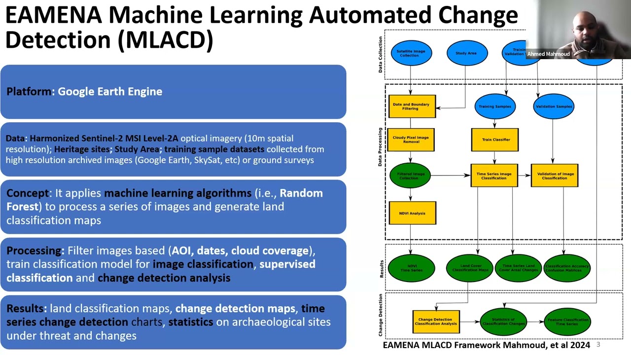
- Ahmed Mahmoud introduces the EAMENA MLACD tool and its purpose.
- Demonstration of the MLACD tool interface and workflow.
- Ahmed Buzaian presents the Lefhaqqa case study and field survey results.
- Muftah Alhaddad discusses the Wadi Bin Ulid case study and training.
- Conclusion and Q&A session.
Cited Sources
- EAMENA GitHub repository — The MLACD tool is available on this repository, as mentioned in the talk.
Concurring Sources
- EAMENA project publications — The project has published research on heritage monitoring and remote sensing, which aligns with the talk's content.
Contribution & Novelties
The talk presents an innovative application of machine learning to heritage monitoring, specifically the MLACD tool, which is open-access and designed for heritage professionals. The integration of remote sensing with field validation provides a robust framework for detecting threats. The case studies in Libya demonstrate the tool’s effectiveness in real-world conditions. The talk also highlights the importance of training local professionals, contributing to capacity building.
Pour aller plus loin :
- EAMENA project — The project’s official website, providing background and resources.
- Google Earth Engine — The platform used for the MLACD tool, offering cloud-based satellite data analysis.
- Sentinel-2 — The satellite mission providing the imagery used in the tool.
- Cultural Protection Fund — The fund that supported the training and fieldwork.
121 words
Radar Profile
The radar profile shows high scores in quantity and quality of information, with slightly lower technical depth. This indicates a well-balanced presentation that is informative and reliable, but may not delve into advanced technical details for specialists.
💬 No comments were provided for analysis.